Maps & Atlases
The Frank P. Zeidler Humanities Room has map and atlas resources that are useful to researchers of Milwaukee and Wisconsin history.
Along with national and international maps, they are described in the library's online catalog, CountyCat. A few of the most frequently used Milwaukee and Wisconsin maps are highlighted on this page.
All of the print materials described below are kept in the Frank P. Zeidler Humanities Room, located on the second floor of Central Library, unless otherwise noted. These items are for reference use only and cannot be checked out of the library. Please call the Humanities Department at (414) 286-3061 with any questions about the collection.
Milwaukee Maps
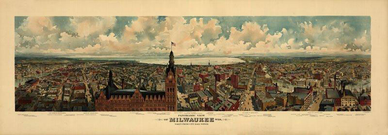
NEW! Selected historic maps of Milwaukee are now available online from MPL!
Milwaukee Maps
The Milwaukee Maps collection was developed as a collaborative project between the American Geographical Society Library (AGSL) , located at the University of Milwaukee-Wisconsin, and Milwaukee Public Library. The maps in this digital collection are from the Milwaukee Public Library’s historic maps holdings, located in the Humanities Department of the Central Library.
Land Survey Maps Land Ownership Maps/Plat Books Fire Insurance Atlases
Early Wisconsin Maps
Wisconsin Public Land Survey Records: Original Field Notes and Plat Maps, from the Board of Commissioners of Public Lands and UW-Madison Libraries
The field notes and plat maps of the public land survey of Wisconsin are a valuable resource for original land survey information, as well as for understanding Wisconsin's landscape history. The survey of Wisconsin was conducted between 1832 and 1866 by the federal General Land Office. This work established the township, range and section grid; the pattern upon which land ownership and land use is based.
Township maps of Milwaukee County, 912.77594 U585 (9 maps)
Photo-lithographic reproductions of the township plat survey of Milwaukee County.
Land Ownership Maps and Plat Books
Wisconsin Land Ownership and Plat Book Index (1858-present)
Central Library's Frank P. Zeidler Humanities Room has an extensive collection of plat books and maps showing property ownership for the entire state of Wisconsin.
Fire Insurance Atlases
Fire insurance atlases (often referred to as “Sanborn fire insurance atlases” after one of the major companies that produced them) are maps that detailed buildings and their construction materials. In their time, they were used to assess potential risk from fire and other hazards in order to set insurance rates, but today they are a tremendous source of historical and genealogical data.
More about Sanborn fire insurance maps, from the Library of Congress (includes basic key to these maps).
Milwaukee Public Library owns five sets of fire insurance atlases for Milwaukee in print format in the Humanities Room:
- 1876 base maps (with paste-on updates to 1885)
- 1888 base maps
- 1894 base maps (with paste-on updates to 1909)
- 1910 base maps (with paste-on updates to 1926)
- 1910 and later base maps (with paste-on updates to 1962)
Digital Sanborn Maps, 1867-1970
Library subscription. Available for use within City of Milwaukee libraries and by remote access to City of Milwaukee library cardholders.
More than 250 Wisconsin communities are represented in this product from ProQuest. The Help file and Frequently Asked Questions pages can help you get started if you are unfamiliar with using the maps. Maps may be printed. Milwaukee maps listed as included in this resource are:
• 1894 base maps (4 volumes)
• 1904 base maps (2 sheets)
• 1910-1937 (15 volumes)
• 1910- Dec. 1951 (15 volumes)
University of Wisconsin - Milwaukee has a digital Sanborn collection, which includes:
• 1894 base maps
• 1910 base maps
UWM also has fire insurance map holdings (print) from around the country at the American Geographical Society Library.
Wisconsin Historical Society has digitized all of their pre-1923 collection of Sanborn fire insurance atlases for Wisconsin cities – 251 cities, 7,770 sheets. Browse to the Wisconsin community of your choice from their About Sanborn Fire Insurance Maps of Wisconsin Communities page. Or use the links below to navigate to the Milwaukee-area maps in this online collection.
Milwaukee volumes:
1894:
Volume 1
Volume 2
Volume 3
Volume 4
1910:
Volume 1
Volume 2
Volume 3
Volume 4
Volume 5
Volume 6
Volume 7
Volume 8
Back to the Local History page
Back to the House History page