Carl Sandburg's Town of Wauwatosa Home Found?
Finding an old address shouldn't be hard. Just check city directories and phone books. Unless it's Pulitzer Prize poet Carl Sandburg's Hawley Rd. home in the former Town of Wauwatosa, which didn't use address numbers until it adopted Milwaukee's 1930 street address grid system.
Over the years, patrons have asked us where was it located. In a 2013 Shepherd Express article, Nathaniel Preus wrote it is one of the things "yet to be uncovered" about Sandburg's time in Milwaukee (1909-1912).
The following addresses for Sandburg are from A Great & Glorious Romance: The Story of Carl Sandburg and Lilian Steichen by their daughter Helga Sandburg and Wright's Milwaukee City Directory:
- 1909: 338 Hanover St., boarder (Post-1930 address, 810 S. 3rd St.)
- 1910: Town of Wauwatosa (not to be confused with the City of Wauwatosa)
- 1911: 907 18th St. (Post-1930 address, 2469 N. 18th St., razed in 1974)
- 1912: 934 Cambridge Ave. (Post-1930 address, 3324 N. Cambridge Ave.)
More than a dozen years ago, Pat DeFrain, a co-worker, searched biographies and newspaper articles about Sandburg. A few mentioned his Hawley Rd. home was near Johnson's Woods. Then 129 acres of undeveloped woodland owned by the Johnson family and bounded by Johnson St. (W. Fairview Ave.), Government Ave. (S. 60th St.), Dickinson St. and Sherman Ave. (S. 68th St.).
Jonathan Gillard Daly's one-person show, The Eagle in Me: An Evening of Carl Sandburg, at the Tandem Theatre made me wonder if we can get closer to finding the exact location of Sandburg's home in the Town of Wauwatosa.
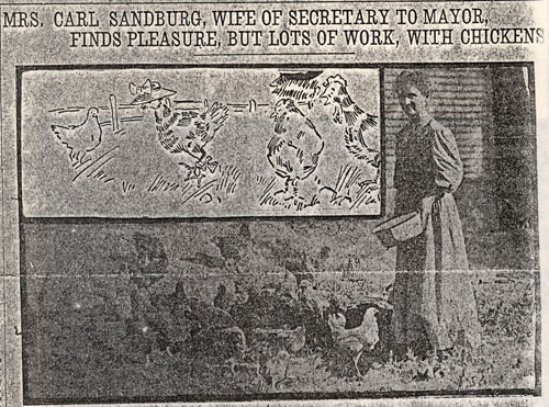
Two books found by Pat are Carl Sandburg: A Biography by Penelope Nivens and the above-mentioned book by Carl's and Lilian's daughter Helga. Both excerpted a September 29th, 1910 article in The Milwaukee Journal about Lilian, nicknamed "Paula" by Carl, raising chickens at their home. Strangely, the article does not appear in the bound newspaper or on microfilm in our collections.
.jpg) |
|
Carl Sandburg Papers (Connemara Accession), 1898-1967, Courtesy of The Rare Book & Manuscript Library, University of Illinois at Urbana-Champaign. |
The University of Illinois Rare Book and Manuscript Library has the Carl Sandburg Papers (Connemara Accession), 1898-1967. Fortunately, they have a photocopy of the full Journal front-page article, which is from a different edition than the issue in our collections or at the Wisconsin Historical Society.
 |
|
The Milwaukee Journal, September 29th, 1910, Helga Sandburg Collection, Courtesy of The Rare Book & Manuscript Library, University of Illinois at Urbana-Champaign. |
What is eye-catching in The Journal article was that the Sandburgs "moved to their present home near the Hawley-rd" and 15 of Paula's chickens were killed by streetcars in front of their house. This means their home was on Johnson St., since streetcars never traveled on Hawley.
Johnson St. was an unpaved road with tracks used by the West Allis branch of what later became known as the #10 Wells-Downer streetcar line. The tracks were originally used by the Downtown-Waukesha-Watertown interurban (light rail) line in the late-1890s. The #10 car line was extended onto the interurban tracks for local service to West Allis in 1906.
Since Hawley was the only paved road in Sandburg's neck of the woods in 1910, this accounts for Sandburg, his family and biographers "locating" his home on Hawley, a practice also used by William Splitt, the 1910 Census enumerator for the Town of Wauwatosa as he walked from house to house in the mostly rural Hawley Rd. area on a cloudy April 30th, 1910.
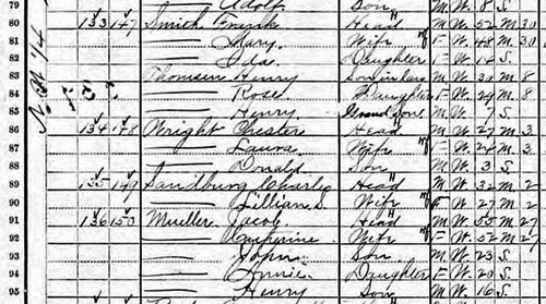
He recorded Charles and Lilian Sandburg as renters. The order of houses visited by the census taker was Frank Smith, Chester Wright, Sandburg and Jacob and Catherine Mueller. Carl used Charles as his first name from childhood since it sounded more American. His occupation was listed as Clerk in the Mayor's Office.
Milwaukee annexed a stretch of land from Story Hill to Hawley Rd. in 1925. The city assigned address numbers to residences and businesses in the newly annexed tract. Henry Mueller, son of Jacob and Catherine, and Smith first appeared in the Milwaukee City Directory in 1926 at 5819 and 5909 Johnson St., respectively. In a short time, the City shortly renamed Johnson St. as Canal St. since it was on the same baseline as Canal St. further east. However, Carl Baehr wrote in Milwaukee Streets: The Stories Behind Their Names that residents objected since there was no canal nearby and Canal conjured images of a seedy waterfront. A year later, Milwaukee relented and renamed the street the more bucolic sounding Fairview Ave.
 |
|
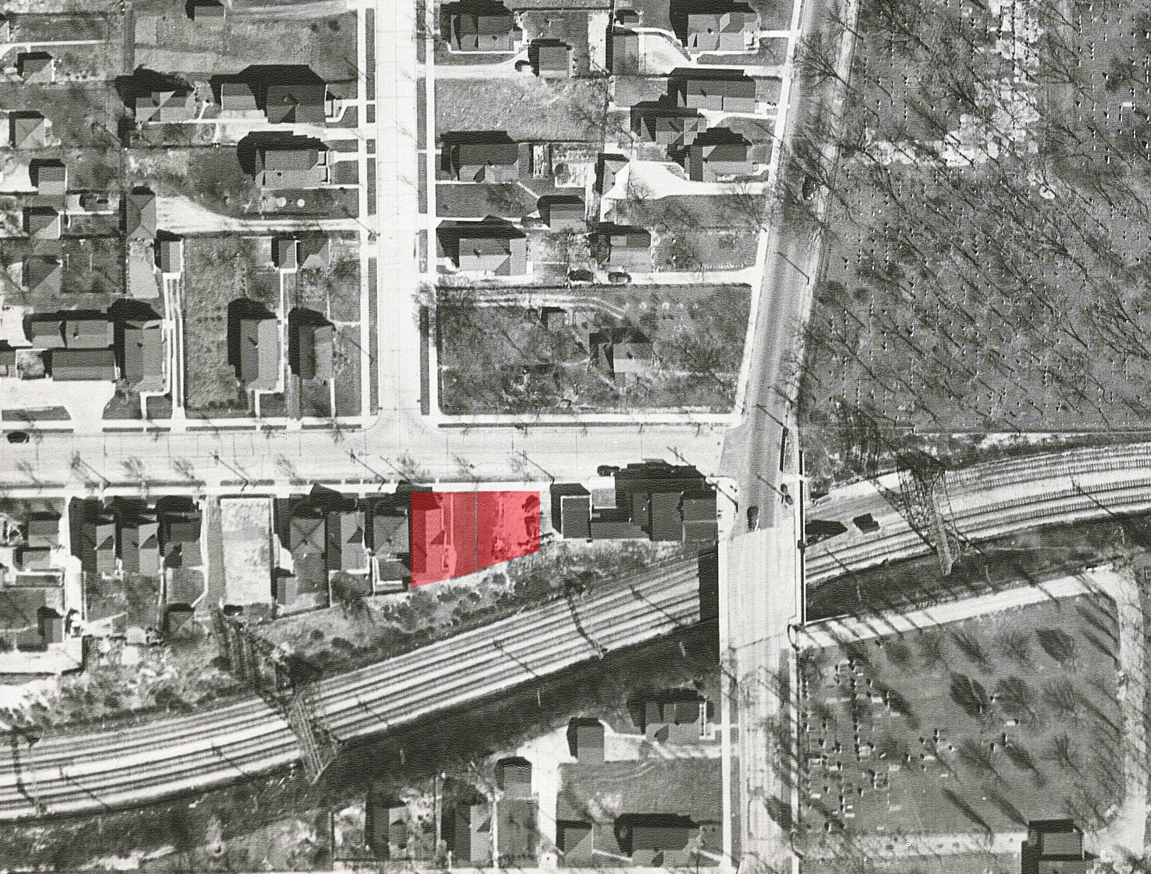
1948 aerial photo of the Maple Wood subdivision with Sandburg's probable home locations highlighted in red. While the house on Lot 38 (left) is visible, the house on Lot 40 (right) was razed when the 4-track Rapid Transit segment was built in 1928. Abrams Aerial Survey Corporation, City of Milwaukee, Department of Public Works. |
The legal description for Mueller's and Smith's lots from the 1926 Milwaukee tax rolls shows they lived in the Maple Wood subdivision. The subdivision map at the Milwaukee County Register of Deeds shows Frederick Kirchman surveyed it for Charles L. Dana and Frank A. Conrad in 1892. Maple Wood consisted of two blocks with 40 lots each and was bounded by Johnson St. (W. Fairview Ave.), Hawley Rd. Morgan St. (W. Dixon St.) and Government Ave. (S. 60th St.). Dana St. split it in half. The search for Sandburg's home narrowed down to Lots 30-40 in Block 1 fronting Johnson St.
By 1956, the Town of Wauwatosa was annexed out of existence by the cities of Milwaukee, North Milwaukee (consolidated with Milwaukee in 1929), Wauwatosa and West Allis. The town's 1867-1956 property ownership tax rolls eventually found a home at the City Records Center of the Municipal Research Center in Milwaukee's City Clerk Office.
 |
|
1910 Census, Encouraged by Paula, Carl Sandburg stopped using Charles shortly before running for the Wisconsin Assembly as a Socialist in fall 1910. BadgerLink, HeritageQuest Online. |
Comparing deeds at the Milwaukee County Register of Deeds, 1909 town tax rolls, 1907 and 1914 (no 1910) editions of the Milwaukee County Directory, and 1910 Census home ownership and rental information on a 1927 fire insurance map from the Digital Sanborn Maps, 1867-1970 subscription database reverse engineered to the April 1910 Census showed census enumerator Splitt walked clockwise on the east side of Hawley from Johnson St., west on Dana (both sides), north on the east side of Government, east on the south side of Johnson and south on the west side of Hawley. If no one was home, he returned later in the day, which explains order discrepancies between different sources.
There were only four houses, Lots 30, 36, 38 and 40 in Block 1, on the south side of Johnson St. fronting the streetcar line. Frank and Mary Smith (Schmidt on the tax rolls) owned and lived at Lot 30. The lack of rental agreements hampers comparing census rental information and county directory listings with property ownership on deeds and tax rolls. Frederick and Clara Falk owned and may have rented Lot 36 to Chester Wright.
Katharina Mueller (Catherine on the census) owned 7 contiguous lots; 38-40 on Johnson and 1-5 on the west side of Hawley. While only her name was on the deeds, her husband Jacob was listed on the tax rolls. There were buildings on five of Mueller's lots. The 1907 and 1914 Milwaukee County directories showed the Muellers lived on Hawley Rd., three buildings south of Johnson St.
A saloon was on Lot 1 at the corner of Hawley and Johnson. The census listed Henry Streng as the saloonkeeper. Houses were on Lots 2 and 5 (Hawley), and 38 and 40 (Johnson). Sandburg and his friend and neighbor Wright had several things in common. They were friends, young reporters and Socialists. Wright was the Socialist candidate for Lieutenant Governor in 1908. Sandburg finished third (25%) in the November 1910 7th Assembly District election covering the cities of Wauwatosa and West Allis, village of West Milwaukee, and unincorporated towns of Wauwatosa, Greenfield and Franklin.
Could Wright and Sandburg rented Lots 38 and 40 from the Mueller family? If Wright lived at Lot 36, then did Sandburg live on Lot 38? Who was the third renter and which house did he or she lived on Johnson St?
While correspondence between Sandburg and Wright in the Sandburg Papers at the University of Illinois briefly allude to good memories with no details, there is no correspondence between Sandburg and his probable landlord, the Mueller family.
In April 1910, Milwaukee voters tired of the corruption and incompetence plaguing the administrations of Mayors David "All the Time Rosy" Rose (Democrat) and Sherburn “Sherbie” Becker (29 year-old Republican "Boy Mayor") elected the Socialists in a landslide to clean house after almost 40 elected and appointed officials were convicted on 276 indictments.
 |
|
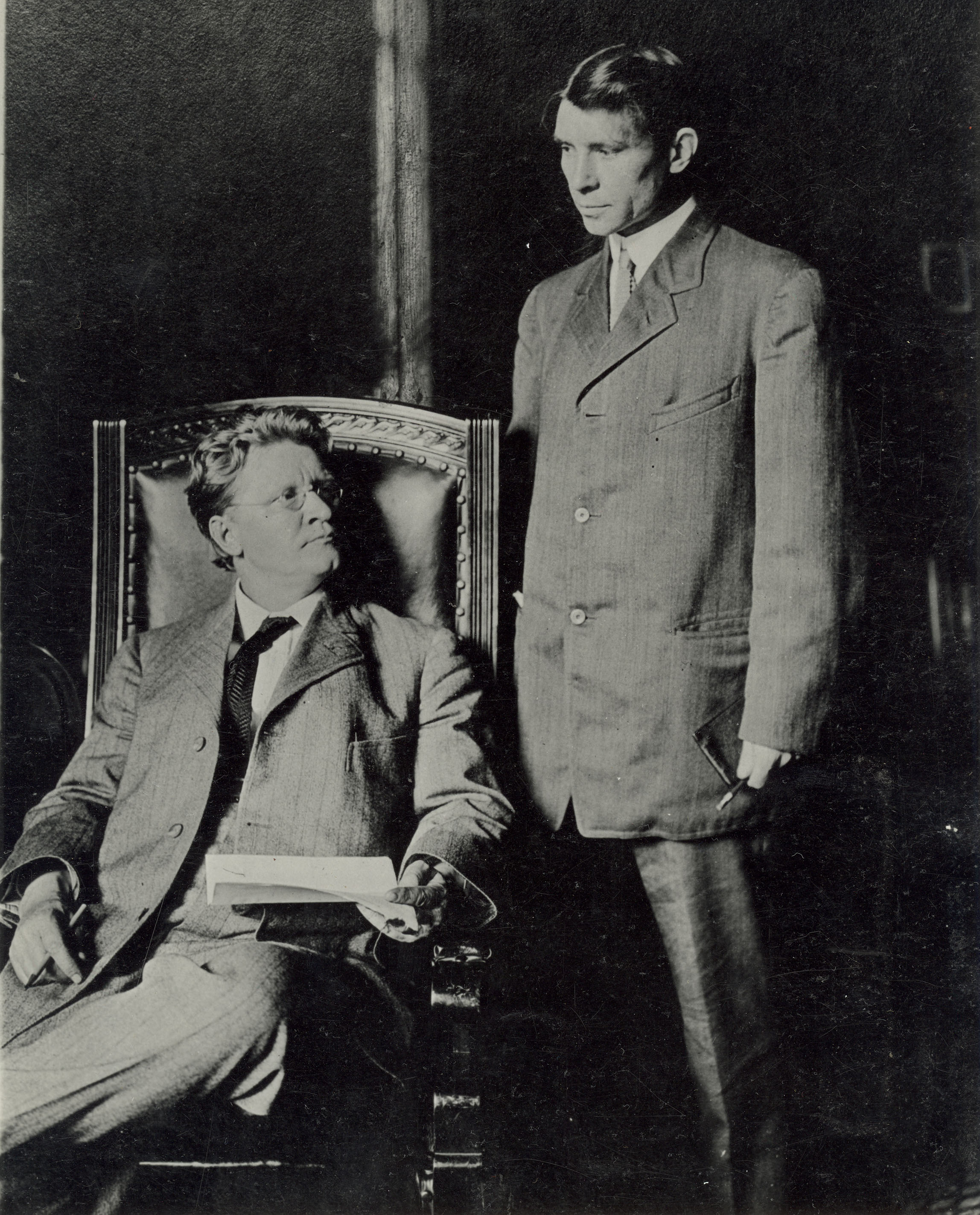
Mayor Emil Seidel and Carl Sandburg (standing), 1910, The Milwaukee Journal, courtesy of Milwaukee Journal Sentinel, Milwaukee Public Library, Historic Portrait Collection. |
Mayor Emil Seidel appointed Sandburg as his secretary. When he was unable to attend the opening of the Milwaukee Public Library's first stand-alone branch, South, on June 16th, 1910, he dispatched Sandburg to present the building from the City to the Library Board of Trustees. In 1911, Sandburg left City Hall to join the weekly Social Democratic Herald and eventually The Milwaukee Leader, a daily newspaper started by the Socialists.
Democrats and Republicans feared neither party would win in another three-way race against the Socialists. They united on a Fusion ticket, dubbed "Rebunkocrats" by Sandburg. Even though the Socialist won more votes in April 1912 than in their 1910 sweep, they lost the Mayor's office and majority in the Common Council to the bipartisan Fusionists. Republicans and Democrats in the Wisconsin Legislature then changed spring local elections from partisan to nonpartisan. However, by 1916 the Socialists had recovered, electing Daniel Hoan as mayor for the next 24 years.
Sandburg and Wright quit The Milwaukee Leader and left Milwaukee in summer 1912 to report for The Chicago Evening World, a Socialist daily newspaper. Sandburg later joined the highly regarded Chicago Daily News and his literary career finally took off.
And as for his and Paula’s Johnson St. home? After Milwaukee annexed the area in 1925, Lots 38 and 40 were assigned the addresses of 5819-5821 and 5813-5815 Johnson St., respectively.
The Milwaukee Electric Railway & Light Co. (TMER&L eventually separated into We Energies and Milwaukee County Transit System) rebranded its interurbans as Rapid Transit and opened two grade-separated right-of-ways from Pigsville to Hawley Rd. and Sherman Ave. (68th) to West Junction (I-894 and Burnham) in 1926. Connecting the two right-of-ways was the Johnson St. streetcar tracks, now shared by the #10 Wells-Downer streetcar (local) and four Rapid Transit lines, West Junction, Watertown, East Troy and Burlington. Rapid Transit ran express from Soldier's Home (Mitchell Blvd.) to Sherman (68th), but was slowed by the #10 cars stopping every two blocks on Johnson St.
Wisconsin General Railway, a land company for TMER&L bought most lots between Fairview (formerly Johnson) and Dana from Hawley to 60th in 1927, but allowed home owners to stay. They razed only a few houses, including 5813-5815 Johnson St. (Lot 40), to build a four-track grade-separated right-of-way with two tracks each for the #10 car and four Rapid Transit lines through backyards from Hawley to 68th (formerly Sherman) in 1928.
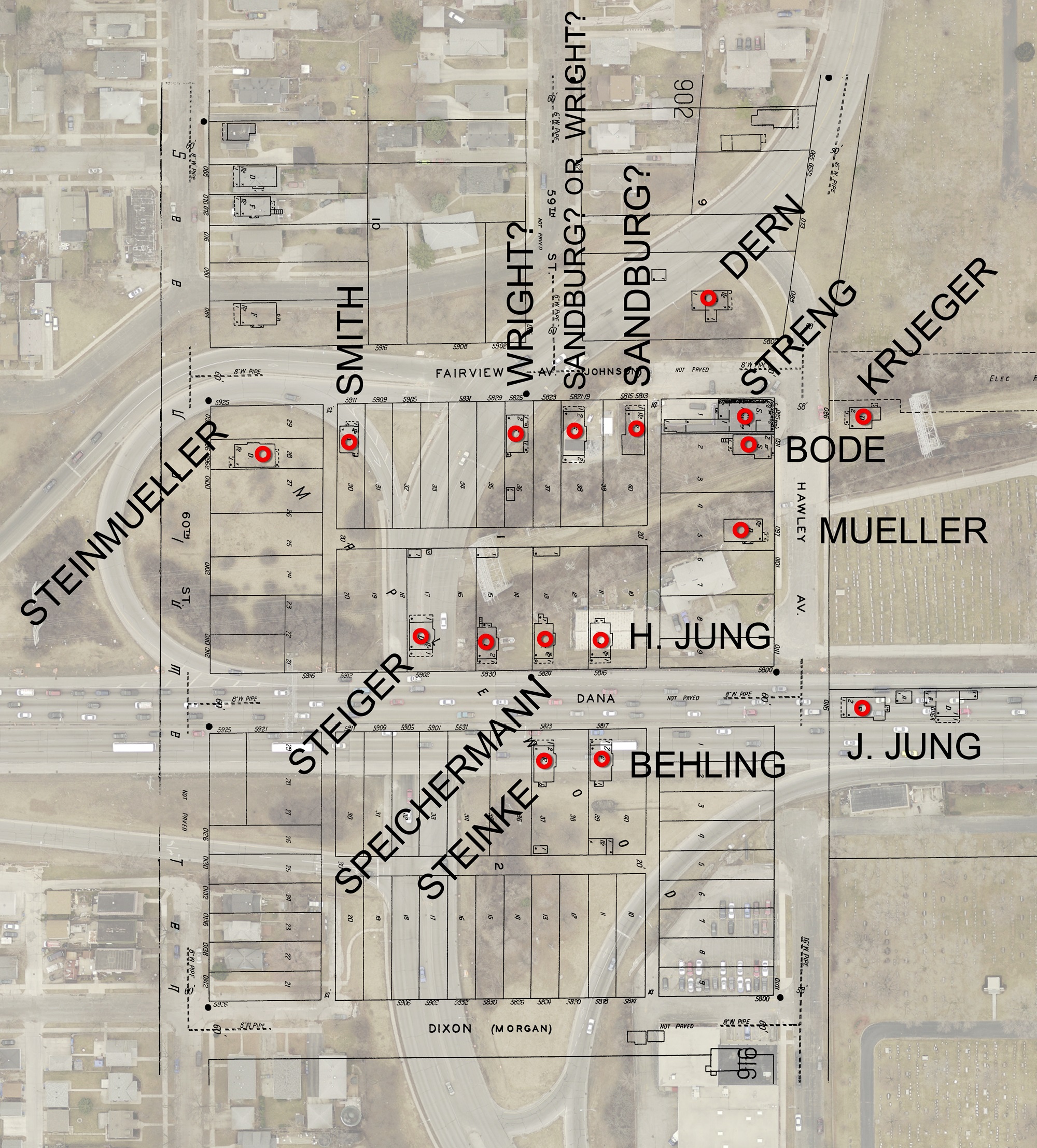 |
| Recent aerial photo of the Maple Wood subdivision overlaid on a 1927 Sanborn fire insurance map reverse-engineered to 1910. City of Milwaukee, Department of Public Works and Milwaukee Public Library, Digital Sanborn Maps, 1867-1970 |
Much more drastic change came in 1959-1960. The Milwaukee County Expressway Commission razed almost every building in the Maple Wood subdivision, including Sandburg's home, for the relocation of Hawley Rd., and construction of the East-West Expressway (I-94) and Hawley Rd. interchange.
Smith's former house on Lot 30 (until 1921) was assigned the address of 5923 W. Fairview Ave. in 1930 and might have been the only house in the subdivision to be moved during expressway construction. The only original building remaining on Sandburg’s block is on S. Dana Ct. ("old" Hawley remnant). This is the approximate location of the two houses that were Sandburg's probable home in Google Maps Street View.
Thanks to Yance Marti for modifying the 1927 Sanborn fire insurance map to show only buildings that existed at the time of the 1910 Census and overlaying a recent aerial photo showing the area as it looks today.
Dan, Local History Librarian
Revised May 14th, 2020. The original posting is available at Internet Archive.