1950 Census Goes Live
 The National Archives released 1950 Census Schedules on April 1, 2022. Visit their 1950 Census Records page for helpful search tips to find genealogical information about parents, grandparents, relatives and famous people that are kept confidential for 72 years after each decennial census.
The 1950 Census name index isn't 100% accurate. For example, Milwaukee Mayor Frank Zeidler (1948-1960) cannot be found by name only. A combination of name and Enumeration District (ED) is necessary to find the majority of people. Many individuals may only be found by the Enumeration District they lived in. The artificial intelligence/optical character recognition (AI/OCR) program may not detect misspellings or decipher cursive and print handwriting of enumerators (census takers). The National Archives is asking people to submit name corrections using the provided transcription tool.
The 1950 US Census Community Project, a joint effort by FamilySearch, Ancestry and other genealogical websites and their volunteers, will take a few months to create a name index.
If people cannot be found by their names but you have their 1950 addresses, you can search by Enumeration Districts. An enumeration district is an area that was canvassed by an enumerator (census taker). Search for an individual or family enumeration district at Steve Morse’s useful Unified 1950 Census ED Finder. The National Archives has a 2-page Milwaukee Census Enumeration Districts map. Enumeration District numbers are red. The City was only 50 square miles then, slightly more than half of its current land area of 96.1 square miles.
If you only have names of people you are trying to find in the 1950 Census, the city directory and telephone book for Milwaukee and some suburban directories from that era are available in the Frank P. Zeidler Room at the Central Library. For available city directories around the United States, you can visit any Milwaukee Public Library location to search Ancestry Institutional Edition. From home, Wisconsin residents can search available directories at BadgerLink. Click Genealogy, then HeritageQuest and finally City Directories.
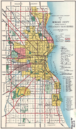 Wondering about the transit and geographical layout of Milwaukee around 1950? Take a look at the maps listed below:
- Milwaukee County 1950 Highway Map
- Transport Co. 1949 Street and Transit Map (No 1950 map in the collection)
- Fall 1951 Milwaukee County Aerial Photograph Map
- Milwaukee County Department of Administrative Services, Land Information Office, Interactive Mapping App - Click Basemap (bottom), click Aerial Photos, slide button from 2020 to 1951.
The chart below is a demographic snapshot of Milwaukee comparing 1950 to 2020:
| City of Milwaukee in 1950 | City of Milwaukee in 2020 |
|---|---|
|
637,392 (13)* 50 square miles Population Density - Metropolitan (County) Area - 871,047 (16) |
577,222 (31)* 96.1 square miles Population Density - Milwaukee County - 939,489 (58) Metropolitan Area - 1,574,731 (40) Milwaukee-Racine Combined Statistical Area - 2,053,232 (33) |
|
White – 96.7% African American – 2.8% Latino – .3% Native American – Asian American – |
African American – 37.8% White – 32.3% Latino – 20.1% Asian American – 5.2% Bi/Multiracial – 3.6% Other – .5% Native American – .4% Hawaiian/Pacific Islander – less than .1% |
|
Public Transit Ridership |
Public Transit Ridership |
|
Daily Newspaper Circulation The Milwaukee Journal – 324,268 Milwaukee Sentinel – 181,189 Kuryer Polski – 27,273 |
Daily Newspaper Circulation Milwaukee Journal Sentinel – 83,628 |
* Milwaukee's ranking among the most populous US cities in 1950 and 2020.
If you can't wait until 2032-2082 for the release of the 1960-2010 confidential Census records but you have names and addresses you're interested in from that period, check the U.S. Census Bureau "Age Search Service" for the qualifications required to apply for Census records transcripts and the search fee.